Visit Greece | Cyclades

The most famous island group in the Aegean Sea comprises some of the most beautiful islands in the world! Gorgeous sandy beaches, architecture in white and blue, traditional lifestyle, folk music, warm, hospitable people and barren landscapes with isolated chapels turn a trip to the Cyclades into a lifetime experience.

The name “Cyclades” refers to the islands forming a circle (the name in English means: “Cyclades”) around the sacred island of Delos. According to the Greek mythology, Poseidon, God of the sea, furious at the Cyclades nymphs turned them into islands.

destination

Mykonos

Mykonos is part of a cluster of islands including Delos, Rhenia and some rocky islets. Mykonos, already inhabited since the 5th millennium B.C. (prehistoric settlement of Ftelia), has shared with them a long and copious history with them. Its intense tourist and cosmopolitan activity, which has continuously kept Mykonos in the foreground, inevitably reminds us of the cosmopolitan ancient Delos during the period of its commercial peak (Hellenistic-roman period).
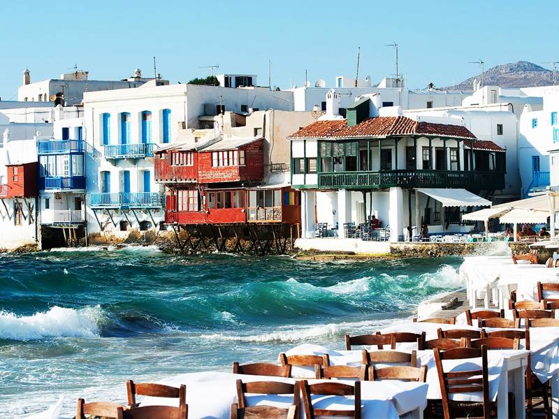
Since the fifties, Mykonos has always been one of the most popular tourist islands of the Mediterranean. Chora, as the town of Mykonos is commonly known, impresses and casts its spell on the visitor from the first moment, with its beautiful position, scale and architecture.

Despite the great tourist development of the island, it manages to maintain its cycladic features and traditional look, like few other towns.
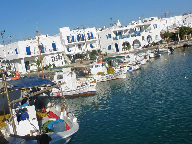
Its cube-shaped, all white houses glow in the sunlight, scattered wisely and orderly in the countless labyrinthine alleys and streets with whitewashed cobbled pavements. A little further, on a low hill, the windmills, having stood for centuries, compose a picture of unparalleled beauty in combination with red domes and bell towers of the countless churches. In the harbor, a small colorful flotilla of caiques and fishing boats completes this unique picture with its vivid colors.

destination

PAROS and ANTIPAROS

The central island of Paros, lying some 8 km west of Naxos, is occupied by a range of hills of gently rounded contours, rising to 764 m in Mount Profitis Ilias (rewarding climb, magnificent panoramic views). Three bays cut deep inland – in the west the sheltered Paroikia Bay, with the island’s capital that serves as the main sailing port and as a yacht charter base; in the north the bay which shelters the little town of Naoussa, which in Roman times was the island’s main port for the shipment of Lychnites marble; and in the east the flat Marmara bay. The whole island is covered with a layer of coarse-grained crystalline limestone, in which lie rich beds of pure marble.

The island’s considerable prosperity has depended since ancient times on agriculture, favoured by fertile soil and an abundance of water, and on the working on marble, which is still quarried on a small scale. In recent years the rapid development of the tourist trade has brought changes in the landscape, the island’s economy and its social structure.

Antiparos

South-west of Paros, separated by a very narrow but navigable channel is the island of Antiparos, the ancient Oliaros. The main town, also called Antiparos, clusters round a Venetian castle. There is a beautiful cave with stalactites on the island.
Off the northern tip of Antiparos you can sail up close to two islets of volcanic origin, which guard the channel. Some 500 m south-west of Antiparos is the small island of Despotiko, with a sheltered harbour on the south. Still farther south-west is the islet of Strongoli, ‘the round one’.

destination

Santorini

The spectacular approach to Santorini by sea, usually entering the caldera from the north-west, is the high point of many yacht charter holidays in the Cyclades.

Thira, the ancient name of Santorini, together with the smaller islands of Thirasia and Aspro are part of a volcanic crater, which has been engulfed by the sea. In the centre are the Kammeni islands, the cones of later volcanoes, which came into being in historical times. Hot springs and emissions of gas bear witness to continuing volcanic activity.
The steep caldera cliffs range in height between 200 m and 400 m, while on the outside the land falls away gradually to the sea, its fertile slopes covered with vineyards.

Yet, the island is treeless due to lack of water, though the inhabitants achieve a modest degree of prosperity through the export of wine, pulses, pistachios and tomato purée. Santorini also possesses a natural resource in the form of pozzolana, a hydraulic cement used in structures exposed to water (harbour works, the Suez Canal).
In more recent years large numbers of visitors have been attracted to the island by its extraordinary natural structure and its excavation sites, which are among the most important in Greece, and the tourist trade has made an increasing contribution to the economy.
Also – with the new Vlichada marina nearly finished (see the bottom of this page) – more and more yachtsmen visit this beautiful island.

Geological history of Santorini

Santorini represents the most active area of the South Aegean Volcanic Arc, which includes the islands of Aegina, Methana, Poros, Milos, Kos and Nisyros. Volcanism in this Aegean Arc generally first occurred about 3-4 million years ago with the exception of Kos where Miocene deposits suggest eruptions 10-11 million years ago.